Big Scenery, Smaller Crowds: 5 Underrated National Parks

With the COVID-19 pandemic entering its second year and many international destinations still off-limits to Americans, our beloved national parks will likely remain some of the top vacation destinations in 2021.
Trying to avoid crowds? Consider one of these gems that offers less people and vehicle traffic, but plenty of show-stopping scenery.

North Cascades National Park, Washington
Snow-covered mountain peaks, deep coniferous forests and pristine lakes fed from the cascading water of over 300 glaciers—this is the North Cascades, an alpine wilderness of solitude and splendor just three hours north of Seattle.
Best Times of Year to Visit North Cascades National Park
According to its national park website, the ideal time to visit the North Cascades is between April and October for best access to low elevation trails and drier conditions. High country hiking is best after the snow melts, generally from July through early October. With hundreds of miles of hiking trails, countless panoramic vistas and picture-perfect campsites, it’s a destination well suited for outdoor lovers. Hikes range from the 2-mile Happy Creek Forest Walk to the all-day Sourdough Mountain trek, but North Cascades is hardly limited to foot traffic and campers.
The North Cascades Highway
A perennial visitor favorite is the North Cascades Highway—also known as Washington State Route 20—which traverses the state from the Olympic Peninsula to the Idaho border. Established in 1896, it’s an old wagon route and often referred to as “Washington’s most beautiful mountain highway”—a bold statement, considering the Pacific Northwest’s abundant natural beauty. (Visitors should consider that while the park is open year-round, the highway is only open when weather accommodates it—usually May through early November.) It’s a stunning drive, gradually ascending 5,500 feet around hairpin turns, and over river gorges and waterfalls with snowcapped mountains looming in the distance.
The road gradually descends into the Methow Valley, a popular recreation area with easy access to the Okanagan National Forest, a diverse natural landscape and adventure playground on the Cascades’ eastern slopes. Visitors especially love Winthrop, an old western town with antique boardwalks, fun shops, restaurants and comfortable accommodations.
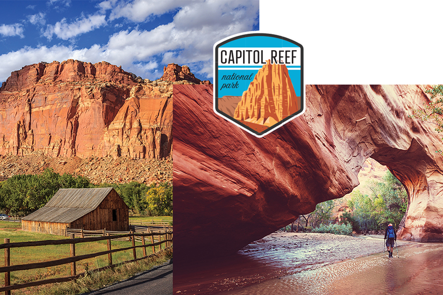
Capitol Reef National Park and Grand Escalante National Monument, Utah
One of Utah’s famous “mighty five” national parks (alongside Zion, Arches, Canyonlands and Bryce Canyon), Capitol Reef is located 58 miles south of Interstate 70, which heads toward Moab and other parks to the east. It can also be reached at the northern end of a spectacular three-hour drive from Bryce Canyon along the Grand Staircase-Escalante National Monument, one of the area’s best-kept secrets.
Geological Wonders and Diverse Biomes
A geologic treasure, the monument covers nearly 1.9 million acres of federally protected, remote backcountry spanning five climate zones, from arid desert to coniferous forest. Hikers and backpackers set off from trailheads in Escalante Canyon off scenic Highway 12, where waterfalls, sandstone cliffs and mountains covered with pine and aspen trees provide a serene, almost primitive backdrop. The remote Grand Staircase region, spanning an area from the North Rim of the Grand Canyon to Utah’s high plateaus, includes a layered succession of multicolored cliffs, shaped over the millennia from lakes, sand dunes and rock. Separating the two is the 1,600-square-mile Kaiporowits Plateau which features sedimentary layers that contain dinosaur and early mammalian fossils dating back 82 million years.
On an eight-day, three-park driving tour, my husband and I traveled north on Highway 12 from Bryce Canyon, stopping for a hike along the Lower Escalante River. Swapping between hiking boots and water sandals as we navigated river crossings, dry sagebrush and the sandy canyon floor, we found occasional shade from stone walls towering 400 feet above us. Back on the highway, we stopped at scenic overlooks to admire the aspen forests all the way to our next home base, Torrey, Utah, and admired the magnificent Capitol Reef, appearing on the horizon where the highway ends.
About 60 miles long and 6 miles wide, Capitol Reef National Park’s desert landscape is defined by a long rocky spine known as a Waterpocket Fold, which traverses the Fremont River. Described on the national park website as a “wrinkle in the Earth,” the Waterpocket Fold is a geologic monocline, a 100-mile upward-thrusted fold in the rock layers. Millions of years of water erosion have created small depressions in the sandstone (known as water pockets), and natural works of art like monoliths, arches, massive red rock cliffs and towering white domes of Navajo sandstone resemble capitol buildings—hence the park’s name.
Scenic Hiking
As experienced national park visitors, we were stunned by the visual magnitude of Capitol Reef. There is nothing quite like it anywhere in North America. A day hiker’s dream, the park offers outstanding scenery on 25 trails ranging from easy to strenuous. The moderate two-hour Chimney Rock Trail—right off Highway 24—climbs just high enough for a view of tilted red rock cliffs and dusty white domes that stretch for miles, before looping back to an easy descent. The family-friendly Cohab Canyon Trail is a 20-minute ascent to the top of the Waterpocket Fold, emerging at a scene reminiscent of a Dr. Seuss book. Black volcanic boulders are scattered along the sandy floor, and narrow pathways weave in and out of side canyons speckled with water pockets, making it an almost otherworldly spectacle.
The Fruita District
Visitors should make time for a stop in the park’s historic Fruita district. The once aptly named Eden of Wayne County was established by Mormon settlers as a small farming community in the late 1870s. Two thousand orchard trees, a schoolhouse and a pioneer home remain and are open daily to visitors. Less than a mile away, and easily visible from the park’s main road, are ancient petroglyph panels carved in the cliff by Fremont and ancestral Puebloan people who lived in the region over 1,000 years ago. The drawings—animals, people and other abstract designs—provide important information about this ancient culture.
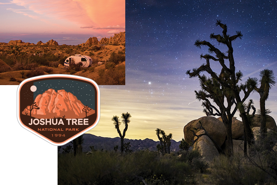
Joshua Tree National Park, California
At the intersection of two deserts in a mountainous corner of southeastern California, a vast, protected landscape is dotted with cacti, groves of palm trees and oddly beautiful Joshua trees, their gnarled, bristle-brush branches fanning out to the desert sky. It’s a captivating vision, especially against the backdrop of giant red rock boulders at sunset. The trees are the main attraction, but are just one of many geological wonders in Joshua Tree National Park.
More than Joshua Trees
Joshua trees are native to the high, cooler elevation of the Mojave Desert on the park’s western side. While they dominate the landscape, other trees, like scrub oak, juniper and pine trees thrive alongside them, interspersed with clustered hills of bare rock and piles of loose boulders. In contrast, dense areas of cacti, mixed scrub, yucca and flowering plants blanket the terrain of the lower-lying Colorado Desert to the east.
Joshua Tree National Park makes a fine day trip from Palm Springs, just 50 miles from its west entrance, off Interstate 10. It’s popular with rock climbers, hikers and stargazers, as well as photographers eager to capture the brilliance of springtime cactus flowers and the desert’s hues at sunrise and sunset. Most visitors make the drive to Key’s View, the park’s highest overlook, for a panoramic view of the Coachella Valley and the infamous San Andreas fault. Wildlife enthusiasts can view over 250 species of birds, as well as reptiles, amphibians, small mammals and a healthy butterfly habitat.
Best Times of Year to Visit Joshua Tree National Park
The best time to visit Joshua Tree is when temperatures are most comfortable (averaging 85 degrees), between October and April. One of the best areas to find plentiful accommodations is along 29 PalmsHighway in Yucca Valley, about 9 miles west of the park.
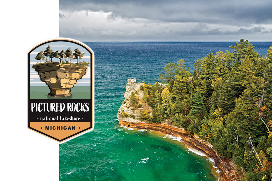
Pictured Rocks National Lakeshore, Michigan
Just a day’s drive away from the Twin Cities is a little pocket of north country scenery so dramatic it’s a wonder many of us in the Midwest have yet to check it off our bucket list. Hugging 42 miles of Lake Superior shoreline in Michigan’s Upper Peninsula is America’s first national lakeshore, where the landscape features white birch forests, unspoiled beaches and miles of multicolored sandstone cliffs towering above the water. Sand dunes, inland lakes, waterfalls, and over 100 miles of hiking and walking trails make for terrific backcountry day hikes and camping excursions.
History in and Around Pictured Rocks
This is a national park with something for everyone in every season, even history buffs. Several maritime sites, including lighthouses, a U.S. Coast Guard station and the Lightkeepers House Museum contain artifacts dating as far back as 1874. More adventurous explorers can peer out just beyond the water’s edge at the northern tip of the park to spot well-preserved shipwreck remains.
Natural Beauty
Of course, the star attraction of the park is the shoreline, its beauty magnified by weather-sculpted cliffs and brilliant rock formations known as the Pictured Rocks. They’re quite a spectacle. Groundwater tinged with minerals in rusty shades of red, white-black, yellow-brown and copper trickles down the side of the cliffs, producing a dramatic splash of color that is best seen from offshore. While kayaking is one way to see this display, it’s risky in Lake Superior’s unpredictable weather conditions. A more popular option, and the best way to capture memorable photos, is with a scenic boat trip provided by Pictured Rocks Cruises, a 50-year-old company offering over two-hour narrated boat rides along the 42 miles of shoreline. Learn more at picturedrocks.com.
Best Times of Year to Visit Pictured Rocks National Lakeshore
The best time to go to Pictured Rocks National Park is June through August, when the weather is most favorable. Accommodations can be found in nearby Munising, Michigan.